


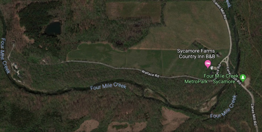
This page provides information about Lane’s Mill, which was added to the National Register of Historical Places in 1980. Unfortunately, the mill no longer exists. The site of Lane’s MIll is located about two miles southwest of the Darrtown (see map below). Directions to the Lane’s Mill site appear below, along with several images of the old structure.
Early settlers of the Darrtown area recognized the flowing waters of the Four MIle creek as a power source for water-driven lumber and grain mills.
The configuration of the Four Mile Creek, near the intersection of Lane's Mill Road and Wallace Road in southwestern Milford Township, offered an ideal location for milling.
A wood-frame mill was built at this site in 1816, which was only two years after the village of Darrtown was established. In 1848, the wood-frame mill was replaced with a handsome and functional stone structure (see images below).
BACKGROUND
Lane's Mill was a combination saw, grist, and fulling mill that was constructed in 1848.
The stone structure that is seen in the photographs on this page was preceded by a wood-frame mill that was constructed on the same site in 1816, just two years after Conrad Darr platted the village of Darrtown.
The mill was added to the National Register of Historic Places in 1980.
Unfortunately, as seen in some of the following images, the mill fell into disrepair in the late 20th century.
The mill was razed, after the turn of the 21st century.
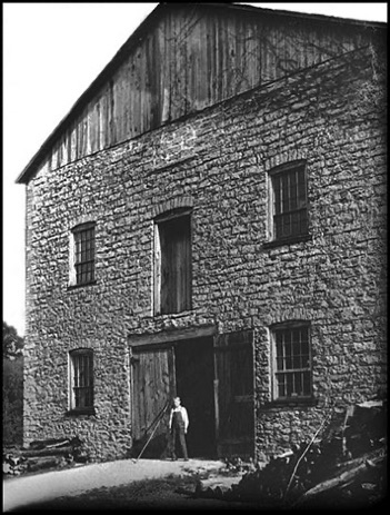
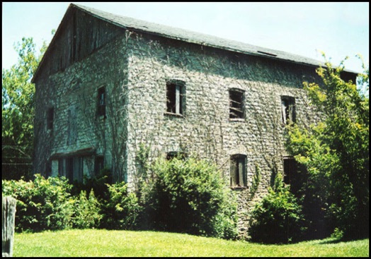
The image at the left is one of the most detailed images that we have of the old mill. The photographer took this shot from the NORTHWEST corner of the mill - standing on or near Wallace Road - looking southeast.
RIGHT:
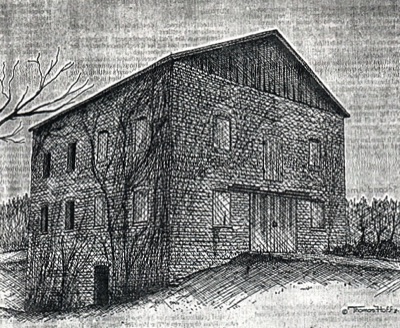
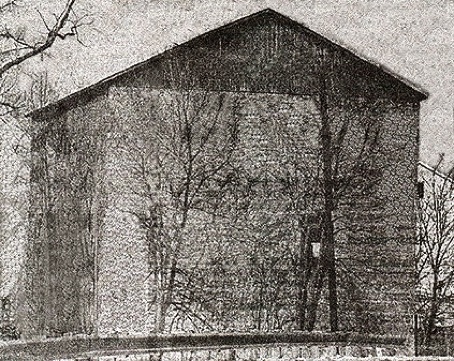
This sketch of Lanes Mill displays the mill from the same side as the photo above.
However, in this sketch, the artist assumed a perspective from the NORTHEAST corner of the mill - standing on or near Wallace Road - looking southwest
LEFT:
This sketch of Lane's Mill appeared in a 1975 Citizens Bank advertisement.
Thomas Hoff is identified as the artist and his work is dated 2-10-75.
The detail provided by Mr. Hoff clarifies the location of windows and doors in the old structure.
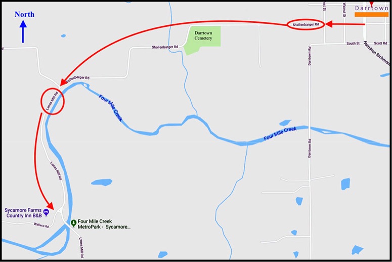
To reach the site of the former Lane's Mill from Darrtown, travel west on Schollenbarger Road.
At the point where Schollenbarger Road intersects with Lane's Mill Road (and turns right to the west), stay left and continue south on Lane's Mill Road, along Four Mile Creek.
DIRECTIONS TO MILL SITE
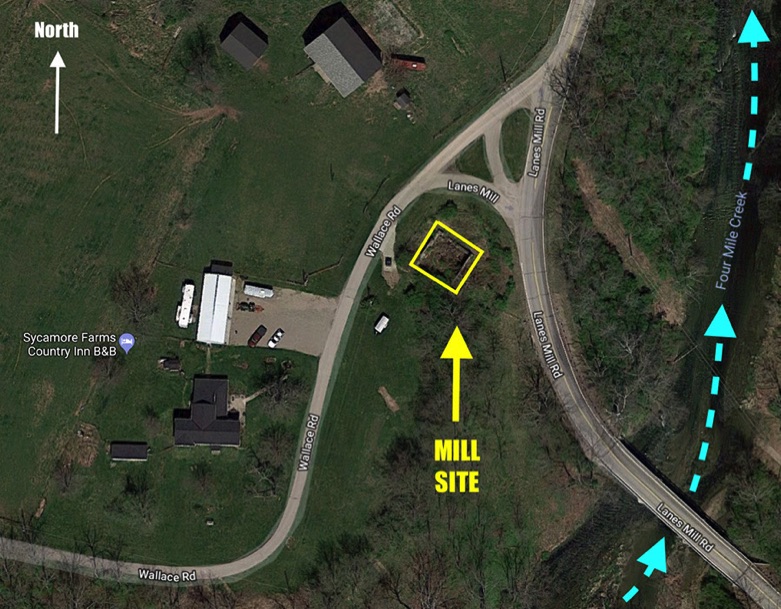
LOCATION OF LANE'S MILL
As indicated by the image below, the mill site is located approximately two miles southwest of Darrtown, on the west side of the Four Mile Creek, near the intersection of Lane's Mill Road and Wallace Road. The mill site is part of the property now (2020) owned by the Sycamore Farms Country Inn B&B.
LANE'S MILL INFO FROM OTHER WEBSITES
MORE LANE'S MILL IMAGES
The two photographs below were contributed by Kirk Mee III. Both images are undated. However, Kirk III reported that the person seen crossing the creek, in the first photo (immediately below) is his father, Kirk Mee II, who was born in 1911. So, it seems reasonable to assume that these two photos were taken during the first quarter of the 20th century.
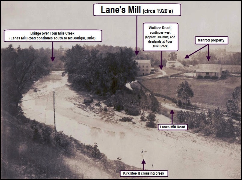
RIGHT: This photo was taken from the top of the bluff that stands on the east side of Four Mile Creek and looks southwest toward Lane's Mill (the three-story stone structure in the center of the photo).
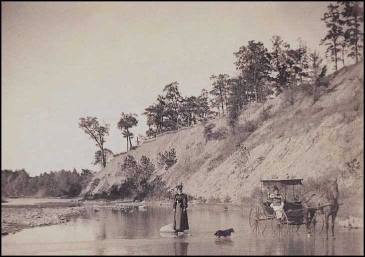
RIGHT: A handwritten note, on the back of this image, referred to the "bluffs" on the east side of Four Mile Creek. That land formation appears in the background of this image. The original photograph also displayed a handwritten caption that read, "Edna in buggy, with Bertha Miller in creek, down by Manrod's." The Kirk Mee I family page contains a reference to John Mee and his sister, Edna - so, the "Edna" in this image may have been Edna Mee.
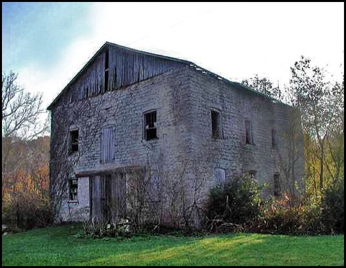
RIGHT: Lane's Mill (circa 2005)
Image found at the
Ohio Barns website
(2012)
LEFT: Lanes' Mill (circa 2005)
Image found at the SciFiCincinnati website
(2012)
More Background on Lane's Mill
In April 2012, Larry and Debbie Garver contributed documents and images about the Manrod family, which included a newspaper article about George Manrod and the old Lane's Mill. See Families - Manrod.
April 2010: The history of Lane's Mill is enhanced by the power of the Internet and a spirit of community!
On April 3, 2012, the following email message arrived at Darrtown.com.
"I live in California and several years ago I acquired at a yard sale a detailed print of the mill of Wm Lane. It details the mill along with all of the buildings and the bridge. I read the articles about how the site is in a state of disrepair. If there are future plans for restoration, perhaps this might be of some use. I would like to donate it so that it becomes a part of the history of the area.
If you are interested in having the print please let me know.
Thank you
Stan J."

Upon receiving Stan's email, I immediately responded and eagerly accepted his offer.
Subsequently, after a couple of email exchanges, I learned that Stan's last name is Jankowski , that he lives in Apple Valley, California, that the yard sale was in Pasadena, California, and that he would send the print to me.
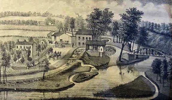
I expected a sketch on paper, probably mailed in a paper envelope. However, when the UPS truck arrived, I received a 15"x12"x3" box that Stan had packaged, addressed, and mailed at his expense. Inside the box, I found a framed illustration of the "Res. & Mill of Wm. L. Lane" (see image below).
So, in addition to receiving an unexpected gift for the Darrtown.com website, I also received confirmation that there are kind, thoughtful, and generous individuals among us. Obviously, Stan Jankowski is such a person. On behalf of the Darrtown online community, a sincere "Thank you!" is extended to Stan Jankowski.
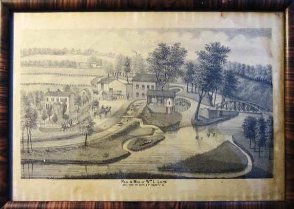
ABOVE: The perspective in this illustration (above) looks north from the south side of Four Mile Creek (which appears in the foreground). The unknown artist was likely positioned in the hills south of the creek to acquire this perspective of looking down upon the Lane farm property.
The Four Mile creek, after flowing past this location - from the left (west) to the right (north) - continues for about 1/2 mile; then, the creek turns east. About one-half mile south of Darrtown, it turns south and continues toward Hamilton, Ohio and the Great Miami River.
The bridge, at the right edge of the sketch, is part of Lane's Mill Road, which can be seen (behind/above the barn), meandering northward along Four Mile Creek.
Wallace Road appears in the foreground-left, running between the creek and the house. Wallace Road intersects with Lane's Mill Road behind the mill, which is the tallest structure in the illustration.
RIGHT:
This is an image of the framed sketch that Stan Jankowski donated to the Darrtown website.
RIGHT: Photo of Lane's Mill - from "Impressions by Allan Miller"
Allan Miller shot this photo
of Lane's Mill.
In May, 2012, Allan agreed to have the image scanned, which led to this copy.
Sandy (Ward) Jolivette deserves credit for contacting Allan and arranging for the scanning of the image.
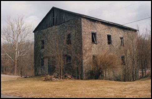
LEFT: This image looks from northwest to southeast. It was shot from Wallace Road, which passes between the now defunct mill site and the barn on the property.
Lane's Mill Road is visible at the base of the large sycamore tree.
RIGHT: Photo of Lanes MIll by Pete Chappars
In addition to shooting this photo, Pete Chappars wrote the following news article about Lane's Mill. The date of publication is not known.
Pete Chappars was a reporter for the Oxford Press, which was published once per week.
Kirk Mee III contributed both items to this website in April, 2018.
LEFT: This is a reprint of the newspaper photo, so the image quality is reduced.
Pete Chappars shot this photo (from southeast to northwest), while standing on the bridge over Four Mile Creek. The railing on the south-side of the bridge, is visible at the lower margin of the image.
The barn on the property is partially visible at the right margin.
Mill placed on National roster
By Pete Chappars
The rock-faced limestone three-story mill at 3884 Wallace Road, the nearby two-story farmhouse, and the mill race have been added to the nation’s official list of significant sites, the National Register of Historic Places.
They are near the intersection of Wallace Road and Lanes Mill Road, two miles southwest of Darrtown.
The announcement came from the Ohio Historic Preservation Offic in Columbus. The sites’ nominations were prepared by Nina N. Maurer of Miami University, Oxford.
Milling has occupied the Lane’s Mill site since 1816.
The present mill was competed in 1848 by William Elliott in response to the local demand for processing Indian corn grown in Butler County, which then was the state’s largest producer. In 1853, Elliot built the fram house adjacent to the mill.
The mill is named for William Lane, who owned it until 1898. Since the 1880’s, the Manrod family has owned and operated the farm, on which the group is located.
The nomination of the Lane’s Mill Historic Group is a part of the ongoing program of the Ohio Historical society to identify sites in Ohio that qualify for National Register status. The National Register is designed to focus public attention on important landmarks and to promote their preservation. It does not alter ownership rights or administrative responsibility for the sites.
Lane's Mill included in 2018 Geological Study at Miami University
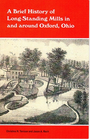
LEFT: This image displays the cover of a booklet that was a product of a 2018 geological study at Miami University of Oxford, Ohio.
The study that gave rise to this publication is titled: "Legacy deposits, milldams, water quality, and environmental change in the Four Mile Creek watershed, southwest Ohio." Lane's Mill is one of five historic mills from in and around Oxford included in the study.
The 18-page booklet, which measures about 5.5" by 8.5", was authored by Christina N. Tenison and Jason A. Rech. It features Images and historical facts about the five mills.
This work is a valuable addition to this website, as it provides, heretofore, unreported details regarding the size, operation, and financial worth of the mill. As noted on page 11 of the booklet, inclusion of the 1920s image of Lane's MIll was approved by the image owner, Darrtown native, Kirk Mee III. Several years ago, Kirk donated the image to the Darrtown.com website. During the 2018 study, researchers at Miami University found the image online and subsequently requested and received permission from Kirk to include it in their study. Kirk received copies of the geological study and the booklet, which he, in turn, shared with this website.
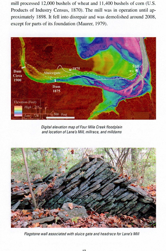
Pages 11 and 12 of the booklet, which provide information about Lane's Mill, are reproduced below.
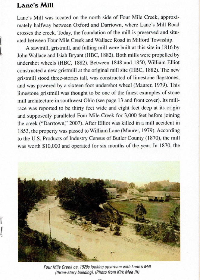
Page 11 of Miami U. booklet
Page 12 of Miami U. booklet
Anecdotal Observations about the Lane's Mill area
Offered by Kirk Mee III - November, 2018
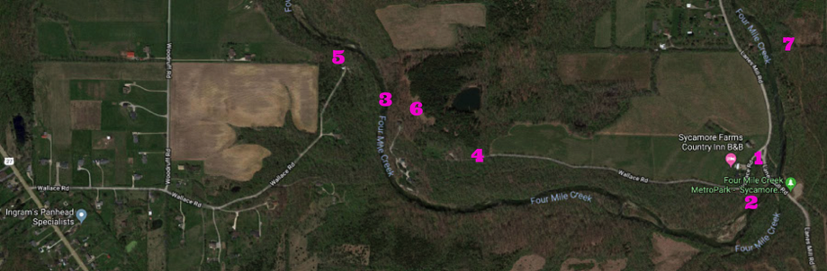
Kirk Mee III, having studied the Lane's MIll area since his boyhood days in and around Darrtown, contributed the following observations about the region. The numerals in the following list correspond to the numerals that appear on the following map.
1 Lane's Mill was situated between the Four Mile Creek and Wallace Road, at the point where Wallace Road intersects with Lane's Mill Road.
2 The earthen mill trace that diverted water from the Four Mile Creek toward the undershot wheel of the mill is still visible along the eastern portion of Wallace Road.
3 Wallace Road is intersected by Four Mile Creek and no bridge exists; hence, the road is divided into two disconnected portions.
4 The eastern end of Wallace Road extends westward from Lane's Mill Road to Four Mile Creek.
5 The western end of Wallace Road extends eastward from State Route 27 to Four Mile Creek.
6 Indian artifacts were commonly found near creek bluffs midway along Wallace Road.
7 An Indian mound was located atop the creek bluffs, where the Four Mile Creek turns north from the location of Lane's Mill.
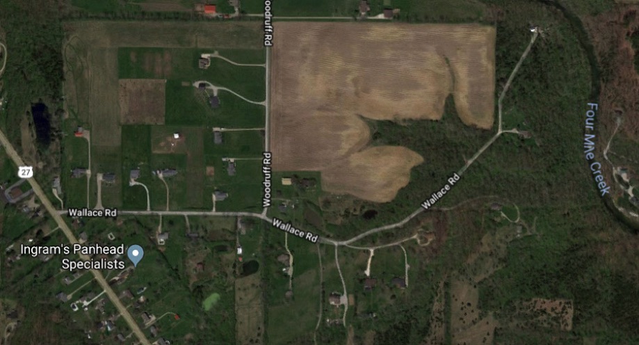
The western portion of Wallace Road begins at St. Rt. 27 and extends eastward and then northeast toward Four Mile Creek.
The eastern portion of Wallace Road begins at Lanes Mill Road and extends westward toward Four Mile Creek.
"Lane's Mill was built in 1848 by William Elliot. William Elliot was killed in an accident in the mill in 1853. William Lane bought the mill and operated it until 1898. The farm complex including the mill, house and barn has since belonged to the Manrod Family.
Lane's Mill is 3 1/2 story beautiful structure. It was built with cut limestone that was quarried from Four Mile Creek, the water supply for the mill. The original roof was shake and was covered in 1970 with asphalt shingles. The building is covered with vines and brush trees that hide the impressive structure. The wooden gables are seriously deteriorated and the windows are gone. Above each window opening is a stone segmental arch lintel. Each window sill has a protruding slab of stone.
The area surrounding the mill is so overgrown that identifying the location of the undershot waterwheel is impossible. The millrace is easily identified. At its origin, the millrace is 30' wide and 8' deep. It becomes narrower as it approaches the mill. The tailrace parallels Four Mile Creek for 3000 feet. The millrace and tailrace have not been changed significantly but they are overgrown with trees and brush.
Although the mill area is not maintained and the mill is seriously deteriorated, it is still worth a visit. Just the stone work alone is architecturally significant. Lane's Mill is listed on the National Register of Historic Places. ('Lane's Mill.')."
The "Old Mills" website contains some images of Lane's Mill, when it was being demolished. The images are replicated here.
In February, 2010, the following description of Lane's Mill appeared at the Abandoned Ohio web site:
"The mill site was established around 1816 when Isiah Bryant and John Wallace built a wood-frame mill.
This particular mill was built in 1848 by William Elliot, where the original mill stood. It was constructed from limestone that was quarried from Four Mile Creek, which was the same creek that supplied the water power to the undershot waterwheel. This was a combination of a saw, grist, and fulling mill. In 1853, a tragic accident inside the mill claimed Elliot's life.
William Lane purchased the mill after Elliot's death. It became known as Lane's Mill from then on. William successfully operated the mill up until 1898. Lane's Mill was added to the National Register of Historic Places in 1980. Despite that, there has been no attempt to preserve or restore it."
A Wikipedia entry reported the following in February 2010:
"The abandoned mill is on Lanes Mill Road, north of Wallace Road. The original mill was built about 1816 by Isiah Bryant and John Wallace, who also operated the mills for several years.
It was rebuilt in 1850 by William Elliott (or Elliot) as a three-story mill, and its owners included James Smiley and later his son-in-law, William L. Lane of Oxford, whose name remains attached to the mill and the road. The Lane's Mill Historic Buildings, 3884 Wallace Road, were added to the National Register of Historic Places in 1980.
The web site of the Ohio Historic Preservation Office of the Ohio Historical Society says: Lane's Mill Historic Group is a significant embodiment of 19th century mill activity in rural Butler County. The mill building, constructed 1848-1850, is also significant as being one of the few and probably the finest representations of stone mill architecture in southwestern Ohio. Lane's Mill occupies a site that has been devoted to mill operations since 1816, and by 1837 was a locally important focal point for the processing of grain and wood.
Butler County in 1850, was the state's largest producer of Indian corn. William Elliot, cognizant of the demands to process this raw material, constructed the large, handsome mill in 1848. It was an undershot variety, powered by a race constructed for the previous mills. In 1853, Elliot erected the frame farmhouse; soon thereafter he was killed in an accident at the mill.
The mill acquired its present name from William Lane, who owned the mill until 1898. The Manrod family owned and operated the farm complex after the 1880s.
The Old Mills website (see: oldmills.scificinnati.com) includes the following information about Lane's Mill.