

Return to the Chaw Raw Hill and Indians page
"1806-circa: About the same time that the Baptist Church was organized, the Methodists began to have preaching in the neighborhood, and some time thereafter built a log church on the Beeler section, at the foot of the western slope of "Chaw Raw" hill. This Church has since become very numerous and respectable, now worships in a handsome frame building in the village. There are a number of graves near the site of the old church, but the house has long since disappeared."
See: Butler County OHGenWeb Project page / Milford Township:pages 562-574
"Our church was established in 1810, when Samuel Beeler deeded one acre of land, west of the village, near Chaw Raw Creek, for religious and educational purposes."
See: https://darrtown.org/organizations/churches/methodist-church/index.html
Listed below are several resources that attest to the existence of Chaw Raw Hill and suggest a general location. While none of them identify a specific location of the land formation, a conclusion is offered at the end of this section.
SOURCE:
Butler County OHGenWeb Project
SOURCE:
History of the Darrtown United Methodist church
Webmaster Note: In his diaries, Mr. MIller routinely refers to the Four MIle Creek as the "Talawanda."
Mr. Jim Blount created "An Index to Butler County Place Names" that is maintained by the Lane Libraries of Hamilton, Fairfield, Oxford, Ohio. Blount refers to the location of Chaw Raw Hill with this sentence: "David T. Jones, in a map in The Story of the Oxford Vicinity, places Chaw Raw Hill near the line dividing Oxford and Milford townships."
See: https://sites.google.com/a/lanepl.org/butler/home/c/chaw-raw-hill
SOURCE:
Jim Blount's "Butler County Place Names"
SOURCE:
The 1933 Diary of Mr. L.A. Miller
In his November 25, 1933 entry, Mr. Miller wrote: … "I see, by the press, that Ohio has full arrangements to build 39 conservation dams on Ohio's rivers. The one on Talawanda, at Chaw Raw, will be ..."
SOURCE:
Recollections of Mrs. Hazel Green
During the interview of Mrs. Green, her son "Butch" Green commented, "You know this sharp curve down here?" (Pointing in the direction of the 90 degree turn in Schollenbarger Road, just south of Hazel's house.) "If you go straight back (due south off Shollenbarger at the first turn) that’s called Chaw Raw Hill."
See: https://darrtown.org/recollections/hazel-gintner-green.html
SOURCE:
Recollections of Mr. Kirk Mee II
The following quotations were excerpted from the recollections of Mr. Kirk Mee II.
"Just two miles west of Darrtown, off Shollenbarger Road is Chaw Raw Hill. It's said that Captain Sam Beeler, with his sons and their families, came there to make the first settlement in Four Mile Valley. They immigrated from Kentucky about 1802 and left the Miami River by Hamilton and followed Four Mile Creek (or Talawanda Creek, the Indian name, which means Winding Waters) until it was dark.
While the sons were making camp, Captain Sam spied a wild turkey going to roost. No rifle fire could be risked for fear of attracting the Indians. So, Sam used a club to kill the turkey. He pulled the feathers off and the sons argued that they couldn't build a fire to cook the bird, because the smoke would betray them. Old Sam was hungry, so he pulled off a leg and ate it raw. That's why it's called Chaw Raw Hill."
Return to the Chaw Raw Hill and Indians page
Webmaster Note: If you have info about the "Beeler section," please share via the link in the footer.
Webmaster Note: If you have info about a "Chaw Raw Creek," please share via the link in the footer.
Webmaster Note: If you have info about David T. Jones - or his book, please share via the link in the footer.
CONCLUSION:
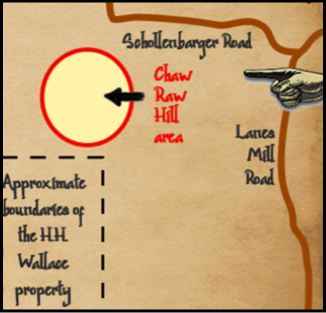
Based on the resources cited above, it seems probable that Chaw Raw Hill was/is located in the area designated by the oval on the map at the right.

Webmaster Note: The search continues for information about the location of the Beeler property in southwestern Milford Township.

Webmaster Note: The search continues for information about the location of the Wallace property in southwestern Milford Township and southeastern Oxford Township.
ABOVE: This map is a portion of a larger, hand-drawn, map on the Chaw Raw Hill page (see link below).
The information that appears in this section was contributed by Marvin Russell.
Marvin found this content on the "Hamilton - Our Old Town" Facebook page. It was posted by Jerry Cook.

June 13, 2022
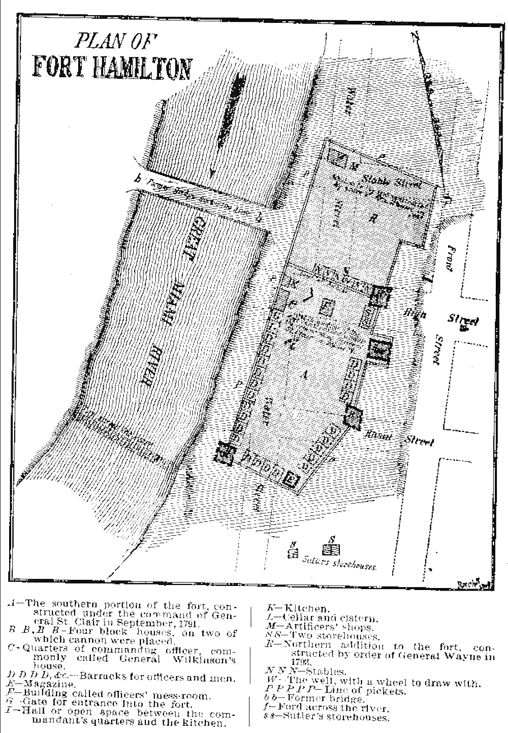
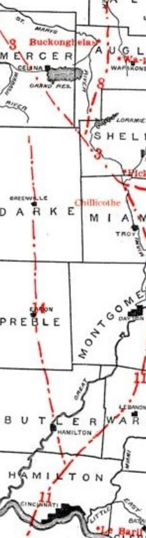
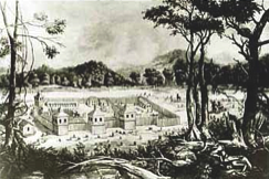
The best place to cross the Great Miami, and the reason Fort Hamilton was built where it is, was an American Bison Miami Indian trail that started at Rossville, Miami River across site old Fort Hamilton. West of Darrtown passed Chaw Raw Hill along 4 Mile Creek. Old road there has been washed away as the creek has shifted its banks past what is now Oxford, Brown Rd going north to the Hueston Woods to Sugar Camp, where road turns right; access road to beach area old Indian Road 1/2 mile from cross of Middle & Little 4 Mile Creeks, where College Corner Rd enters Park, passed the Indian Mound, at far west end of primitive camping on ridge above the Little 4 Mile. Long winding gully south-east corner of camp is probably the Road climbing out of 4 Mile creek bed where settlers could pull their wagons. On the Eaton Pike, from College Corner, south of Buck Paxton Rd it crossed ravine. Early deeds identify this as "the Indian Road from Muncytown to Ft. Hamilton".
The following information qualifies for inclusion on this web page as it is a documented reference to the existence and location of Chaw Raw Hill (see bold text below).
Click the following links to see:
Fort Hamilton - Ohio Territory