

This structure is/was strategically located near a loop in the Four Mile Creek, where it crosses the Oxford/Milford Township line. Details (provided below) came from MacLean's book.

--
The name "Chaw Raw HIll" is derived from a story about a night in the wilderness, back in the early 1800s, when a Milford Township settler chose to eat a raw turkey leg - rather than roast the bird over an open fire and risk being discovered by Indians.
To learn more about the raw turkey leg story and to see a LIST OF RESOURCES that attest to the existence and location of Chaw Raw Hill, visit: Documented References.
Land formations built by Indians appear throughout North America. One of them, located in Ohio's Adams County, is known as the Serpent Mound. At 1,348 feet-long and three feet-high, it is the largest serpent effigy in the world.
The Ohio History Connection provides a Serpent Mound webpage.
Wikipedia offers information about the historic Serpent Mound.
Cincyborn provides a YouTube video about Ohio's Serpent Mound.
The MAN-MADE land formation straddles the township line - just south of the point where the Four Mile Creek, after entering Milford Township for the first time, returns to Oxford Township, and then re-enters Milford Township.
BELOW: These two aerial images (from Google Maps) show the loop in Four Mile Creek, as it crosses and recrosses the township line between Oxford and Milford townships. The red arrows indicate the flow of the creek, around the loop.
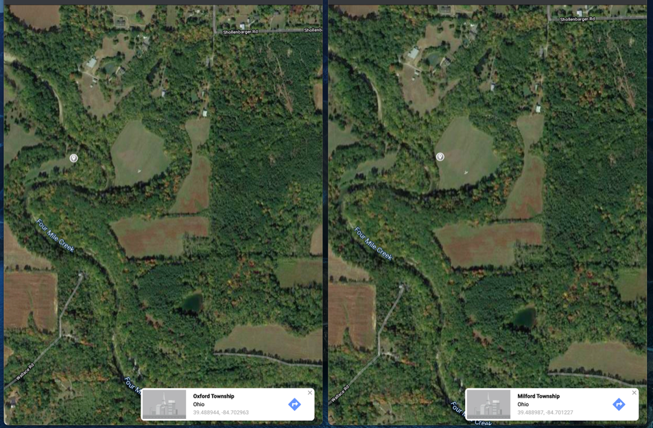


GPS marker

ABOVE: The two GPS markers are only a few hundred yards apart; yet they are situated in two different townships.
A marker has been inserted on each image to establish a GPS ("global position"). The latitude and longitude numerals for each position appear at the bottom of each image.
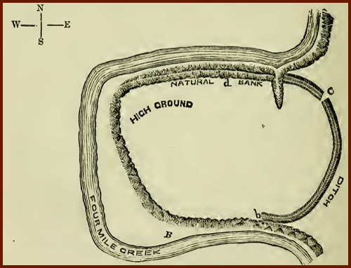
The drawing shown at the right appears on page 204 of J. P. MacLean's 1893 book, "The Mound Builders." The loop in the Four Mile Creek is related to the discussion of an Indian-made land formation in southwest Milford Township.
Notice that MacLean's drawing depicts a land formation INSIDE the loop, which the author describes as "an ancient fortification."
MacLean adds that it (the land formation) "occurs on the land of H.H. Wallace." (The Wallace property, in Milford Township, is cited on the hand-drawn map above.)
Other maps show a township line crossing the fortification in a north/south direction. For example, see McBrides's 1836 map of Milford Twp. - Section 31
THE INDIAN-MADE LAND FORMATION
- located in "loop" of Four Mile Creek
Its just an obscure hill ... located in a wooded area, in the southwest corner of Milford Township ... that few people have ever seen or noticed.
So, how and/or why did this particular hill acquire a name?
This page provides information about TWO HISTORIC LAND FORMATIONS in the Darrtown / Milford Township area.
Location of Chaw Raw Hill
Click the following link to access a downloadable version of MacLean's 1893 book in PDF format.


The NATURAL land formation, known as Chaw Raw Hill, is believed to be found in the area that is designated by the larger oval at the left. The exact location has not been been determined.

The specific location of the natural land formation (Chaw Raw Hill) is not known. However several documented references suggest that Chaw Raw Hill was located in the vicinity that is designated by the larger oval on the map below.
The location of the Indian-made formation, which is signified by the smaller oval on the map below, is based on an 1893 book written by J.P. MacLean, Ph.D.
> 1. One land formation was an unnamed, INDIAN-MADE, land formation.
> 2. A second land formation is known as Chaw Raw Hill and it is a NATURAL land formation.
This map is not drawn to scale.
THE NATURAL LAND FORMATION
- located in southwest Milford Township
LOCATIONS WHERE THE FOUR MILE CREEK TWICE CROSSES THE TOWNSHIP LINE
The image at the LEFT/below shows a GPS marker on the WEST side of the creek...IN OXFORD township.
The image at the RIGHT/below shows a GPS marker on the EAST side of the creek...IN MILFORD TWP.
Those portions of MacLean's text that are pertinent to the discussion of Milford Township land formations are available at: Excerpts from McLean's 1893 text.
The larger yellow oval on the map at the left shows the general area of Chaw Raw Hill.
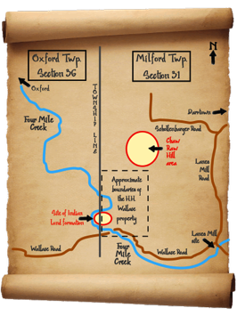
The following image and map offers another view of the general area where Chaw Raw Hill is located.
(A larger view of this map appears near the top of this page.)
