

These following links connect to information related to Darrtown and Milford Township people and places.
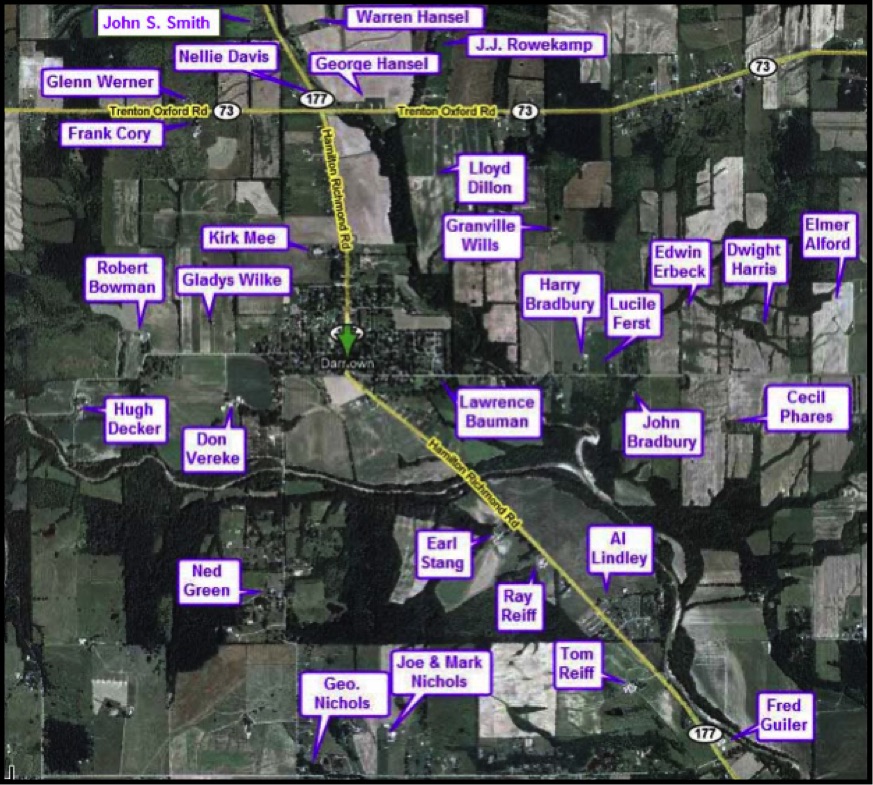
1955 MAP OF DARRTOWN AREA FARMERS
The image below identifies Darrtown-area farmers in 1955.
More information about many of these farmers is available at the "Individuals" page.
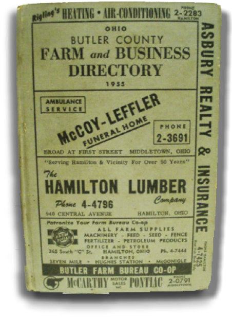
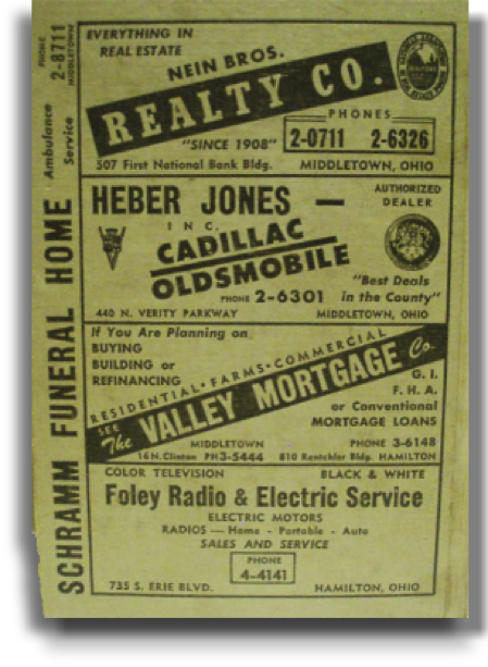
1955 DIRECTORY OF BUTLER COUNTY FARMS AND BUSINESSES
The two images below show the front cover (left) and the back cover (right) of a 1955 Butler County Farm and Business Directory. The directory was the property of Albert Lindley.
1955 businesses that sponsored the Directory included: Rigling's Heating and Air Conditioning, Hamilton; Asbury Realty, in the First National Bank Building, Hamilton; McCoy-Leffler Funeral Home, Broad at First St., Middletown; Hamilton Lumber, 940 Central Ave., Hamilton; Butler County Farm Bureau Co-Op, 365 South "C" St. , Hamilton (with branches in Seven Mile, Hughes Station, and McGonigle; McCarty Pontiac, in Middletown; Nein Realty Company, 507 First National Bank Bldg. in Middletown; Herber-Jones Cadillac & Oldsmobile, 440 N. Verity Parkway, Middletown; Valley Mortgage, 16 N. Clinton, Middletown; Foley Radio and Television, 735 S. Erie Ave., Hamilton, Schramm Funeral Home in Middletown, Miami Cement Products, Ritter St., Seven Mile; Home Federal Savings and Loan, corner of Third & Court Sts.; Long & Meyers Insurance, 1345 Central Ave., Middletown office (next to the Strand Theatre); Wayside Service, corner of State and Miami Streets in Trenton; Trenton Coal and Coke, 42 Potter Street, Trenton; Kennedy-Dare Realty Company, 152 HIgh St., Hamilton; and the Butler County Lumber Company, 961 Main St., Hamilton.
Notice that the phone numbers of the various businesses in 1955 are comprised of only five digits.
Bauer Road (East from Hamilton Eaton Road [Old Rt. 127] to State Road: Farley, W. / Rich, W. / Thomas, J. F. / Hall, O. / Haines, Melinda / Frances, C. / Van DeGriff, G. C. / Davis, J. M. / Brannon, H. / Carpenter, R. / Brannon, H. / Shepherd, T. / Abrams, L. S. / Abrams, D. / Whaley, W. / STATE ROAD RUNS NORTH AND SOUTH.
Darrtown Road (West from Darrtown and south to Hanover Township Line): Popst, H. L. / Carroll, H. / Rose, E. / Gilley, C. / Williams, L. C. / Lane west / Green, Ned / Ward, G. / HANOVER TOWNSHIP LINE
Depot Road (West from Wayne-Milford Road to dead end): Russell, P. / Blakley, P. W. / Ross, E. (Smith, W.) / DEAD END.
Earhart Road (West from Hamilton Richmond Road [Rt. 177] to Oxford-Milford Road): Falk, W.
Eaton Road (North from West Taylor School Road to Hamilton-Eaton Road [Old Rt. 127]): Kehr, F. W. (Vogel, Elizabeth) / Hughs, A. / Lagedrost, C. / Jerold, A. L. / Schuster, A. / Smith, M. / Bufler, L. B. / Wilson, E. K. / Bowman, R. / Brown, G. R. (Bramlage, Catherine) / Brown, G. R. / Ledwell, W. F. (Bowman, G. F.) / Cramer, J. / HAMILTON-EATON ROAD RUNS NORTH AND SOUTH.
Frazee Road (West from Somerville to Oren Road): Peck, C. / Ross, N. / Sims, E. / Staley, D. / Shutte, H. / Johnson, L. / Evans, W. / Burns, E. C. / Farmer, J. / Warner, L. H. / Smith, E. / OREN ROAD RUNS NORTH AND SOUTH.
Hamilton-Eaton Road [Old Rt. 127] (North from Wayne-Milford Road to Somerville): Petry, L. / Superior Feed Mill / Schollenbarger, J. E. / VILLAGE OF COLLINSVILLE / Harris, S. / Cottonwood Picnic Grocery / Cottonwood Garage / Richter, C. T. / Bowers, W. / Bowers, L. C. / DeNeene, J. / OXFORD MIDDLETOWN ROAD BEGINS WEST / Blakely, E. R. / Blakely, R. W. / Finlay, Nora / Finlay, H. / Vacant Building (Finlay, Nora) / Bundy, P. / Ledford, A. Jr. / Marcum, C. / Byrge, W. / Shearer, R. / Flaherty, J. / McHargue, C. / SOMERVILLE ROAD BEGINS WEST / Crutcher, C. / BAUER ROAD BEGINS EAST / Eiler, Roy / Withrow, E. / Mondello, J. / Roll, Marion / VILLAGE OF SOMERVILLE.
Hamilton-Richmond Road (North from Rt. 73 to the Preble County Line): Hansel, Warren / Smith, John / Geiser, Lawrence / Kirkpatrick, H. / Kramer, F. / Pfaff, Clem / Geraci, V. / HARRIS ROAD CROSSES / Krebs, Charles / Conrad, E. / Gray, H. / Francis, G. / Gray, R. / McMillian, P. R. & Kennedy, Myrtle & Kennedy, R. / SOMERVILLE ROAD CROSSES / three vacant buildings: Keller / Wert, J. C. / Ferris, J. S. / Sebald, C. W. / OREN RD. BEGINS NORTH / Beiser, C. / EARHART ROAD BEGINS WEST / Thomas, W. / Von Dron, E. / PREBLE COUNTY LINE.
Hamilton-Richmond Road (South from Darrtown to Hanover Township Line): Lane west at State of Ohio Roadside Park (south of Four Mile Creek) Proffitt, R.; Dees B.; Dunniba, C.; Dees B.; Mullins, M.; Robinette, D.; Badger, Eldie; and Ross, E. / Menke, E. / Stang, Earl / Reiff, Ray / Lindley, Al / Glarden, Ernie / HANOVER TOWNSHIP LINE.
Harris Road (East from Rt. 177 to Hamilton-Eaton Road [old Rt. 127]): Phillips, J. C. / Hensley, T. / Yauger, Roy / Harden, H. / Gabbard, E. B. / Richardson, L. J. / Taylor, Nellie / Benge, W. R. / vacant house (Nellie Burge) / Burge, L. W. / Anthony, N. / Hoffman, E. / Wagonfield, G. W. / Wright, H. / Taylor, W. K. / Huffman, R. / Unzicker, Emerson / OLD ROUTE 127.
Harris Road (West from Rt. 177 to Oxford Milford Road: Gaiser, L. J. / Heinlein, F. / Carter, C. / Carter, W. / Boyle, C. / Laughlin, H. / OXFORD MILFORD ROAD RUNS NORTH AND SOUTH.
Huston Road (South from Collinsville to Milford Township Line): Schwab, J. H. / Gillespie, Clarence / Hoffman, W. / SCOTT ROAD BEGINS WEST / Prescott, E. H. / Marsh, J. H. / Brown, R. J. / Wyatt, C. E. / WEST TAYLOR SCHOOL ROAD CROSSES.
Oren Road (North from Hamilton-Richmond Road [Rt. 177] to Preble County Line): Keller, C. C. / FRAZEE ROAD BEGINS EAST / Snavely, E. / Reichel, W. / Vacant house (Snavely, Edw.) / PREBLE COUNTY LINE.
Oxford Middletown Road-EAST SIDE OF SEVEN MILE CREEK (East from western dead end to Wayne-Milford Road): Wanee, R. A. / Chaney, E. C. / Gerber, P. F. / STATE ROAD CROSSES NORTH AND SOUTH / Moak, C. A. / WAYNE-MILFORD ROAD BEGINS SOUTH.
Oxford Middletown Road-WEST SIDE OF SEVEN MILE CREEK (East from Rt. 177 to Hamilton-Eaton Road [old Rt. 127]): Clark, D. / Ling, G. C. / Lang, O. / Russell, H. D. / Lintner, Bill / Finlay, J. S. / Bailey, E. / Wirtz, E. / B & O RR CROSSES / Van Osdol, R. / Kelly, O. / OLD ROUTE 127.
Oxford Middletown Road-WEST SIDE OF SEVEN MILE CREEK (West from Rt. 177 to Oxford Milford Rd.): Clark, D. / Hunkler, J. / Tutas, J. / Tharp, R. C. / Bobbit, C. W. / Coy, R. A. / Gault, C. L. / OXFORD MILFORD ROAD RUNS NORTH AND SOUTH.
Oxford Milford Road (North from Trenton-Oxford Road to Earhart Road): Gentry, R. W. / Boesel, M. W. / Smith, J. / HARRIS ROAD BEGINS EAST / Port, J. C. / Fillager, H. F. / Fillager, Tillie / BONHAM ROAD BEGINS WEST / Riley, A. / Rosenbalm, E. E. / Retherford, A. / Peck, Cora / SOMERVILLE ROAD CROSSES EAST AND WEST / Isaacs, L. / Jewell, P. M. / Gurr, W. / Stang, T. Jr. / Stang, T. Sr. / EARHART ROAD BEGINS EAST.
Oxford-Trenton Road [Rt. 73] (East from Rt. 177 to Hamilton-Eaton Road [old Rt. 127] at Collinsville): Hansel, George / Hess, J. L. / Rowekamp, J. J. / Dillon, Lloyd / Godfrey, E. / Napier, R. J. / Bunder, R. H. / Schlabach, E. / Cropenbaker, S. L. / Imhoff, Roy / Meehling, R. / Tuggle, W. G. / Collinsville Cemetery / HUSTON RD. CROSSES / Hively, Louella / Holmes, J. / Snider, E. / vacant house (new) Elwell / Bising, A. / Truster, E. A. / OLD ROUTE 127.
Oxford-Trenton Road [Rt. 73] (West from Rt. 177 to Oxford Township Line): Davis, Nellie / Cory, F. B. / Cory, F. M. / Werner, G. W. / Sponsel, Minnie F. / Powell, A. F. / Middaugh, J. / Thompson, E. T. / Brown, J. E.; Lester, Patricia; Brown, C. D. / Bishop F. / Couiter, R. E. / Rhodus, E. C. / Vogel, J. R. / SCHOLLENBARGER RD. BEGINS SOUTH / Funk, C. / OXFORD-MILFORD ROAD BEGINS NORTH.
Scott Road (East from Darrtown to Huston Rd): Bauman, F. / Vacant House (Bauman) / McVicker, L. / McVicker, C. D. / Wills, Granville / Witherby, Charles / Bradbury, Harry / Willer, R. / Ferst, Lucile / Bradbury, John / Erbeck, E. J. / Quick, J. W. / Phares, Cecil / Harris, Dwight / Alford, Don / Lane south; Anderson, Grace; Hess, M. / Alford, Alvin / Montague, L. F. / HUSTON ROAD RUNS NORTH AND SOUTH.
Somerville Road (East from Rt. 177 to Hamilton-Eaton Road [old Rt. 127]): Hurley, Bessie / Hurley, V. / Thompson, T. / Heinlein, P. / Grewe, J. / BAKER RD. BEGINS NORTH / Harbaum, H. / Campbell, H. / NEANOVER RD. BEGINS NORTH / Bolser, H. / PENN RR CROSSES / Blossom, G. / Sizemore, P. / OLD ROUTE 127.
Somerville Road (West from Rt. 177 to Oxford Milford Rd.): Burns, W. E. / Keller, G. / Hill, H. T. / Ramsey, A. L. / Burns, J. E. / Alford, A.
State Road (North from Hamilton Eaton Road [Old Rt. 127] to dead end): B&O RR CROSSES / Williamson, C. F. / Brown, G. R. / Beiser, W. F. / Gerber, J. A. Jr. (Harden, Loree) / Steele, N. P. / EAST OXFORD MIDDLETOWN ROAD CROSSES / Graf, A. / Walther, C. Jr. / Coombs, S. A. / BAUER ROAD BEGINS WEST / Christopher, V. J. / SOMERVILLE JACKSONBURG ROAD [RT. 744] CROSSES / Barton, R. L. / Roesel, H. / Brady, A. H. / UNDEVELOPED ROAD FOR APPROXIMATELY 1/4 MILE TO PREBLE COUNTY LINE.
Wayne-Milford Road (North from Hamilton-Eaton Road [Old Rt. 127] to Oxford-Middletown Road-EAST): Smith, S. C. (Rawlins, F.) / DEPOT BEGINS WEST / Sollenberger, H. N. / TOLBERT ROAD BEGINS EAST / Mann, E. D. / Lane to the west / McWhorter, L. (Edwards, E.) / Lane to the west / Pratt, C. T. (Winkler, A.; Abrams, Irene) / Fields, E. / Hardy, T. / Baker, F. A. / Travillian, G. L. / Vacant trailer (Elliots) / Vacant house (Mirda) / Gregory, J. M. / Stock, E. / OXFORD-MIDDLETOWN ROAD (EAST) BEGINS WEST
1955 MILFORD TOWNSHIP RESIDENTS
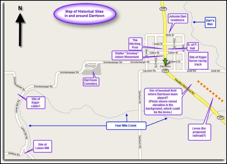
If you know of historical sites in the Darrtown area that deserve to be added to the following illustration - or if you have information that is more accurate than that which is shown in the image below - please contact the Webmaster.
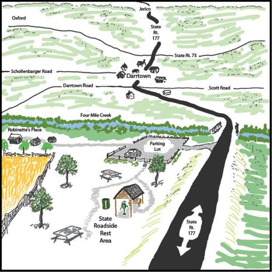
MAP OF HISTORICAL SITES IN AND AROUND DARRTOWN
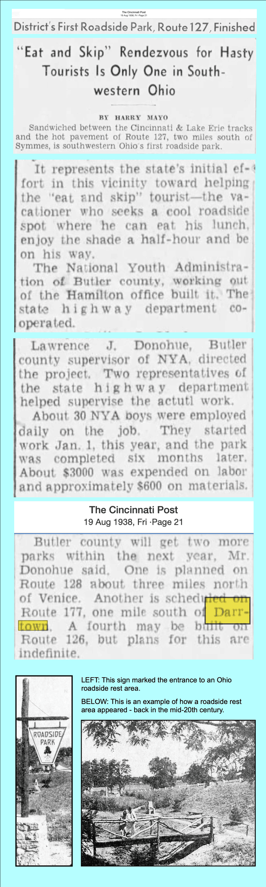
ROADSIDE REST AREA REMEMBERED
During the middle decades of the 20th century, the Ohio Department of Transportation maintained a roadside rest area south of Darrtown on the west side of State Route 177. The diagram at the right depicts the layout of the park, as remembered from many years ago. The view is looking from south to north.
The entrance to the rest area was located immediately south of the Four Mile Creek bridge. Denny Robinette's residence, which is described in Harlan Miller's recollections, was accessed by driving through the parking lot and proceeding west about 100 yards down a private lane.
The manual water pump in the rest area was the kind that would deliver water a few moments after one stopped pumping the handle, thus an individual could secure drinking water, without the help of another person.
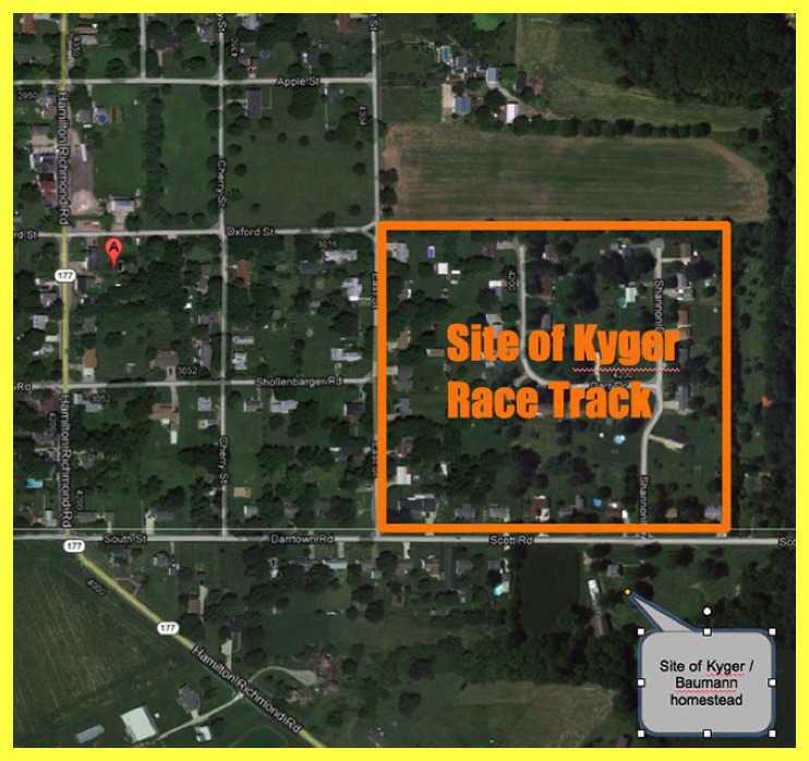
KYGER FARM IS SITE OF FAMOUS RACE TRACK
Darrtown history is intertwined with the history of the Kyger family, which includes the saga of Kit Curry, a famous trotter owned by H.D. Kyger. Narrative records indicate that H.D. Kyger's property featured a race track.
A logical question followed; where was the race track located? An attempt to verify the location of the Kyger race track was undertaken in February 2012, in conjunction with plans to commemorate Darrtown's Bicentennial in 2014. Research (led by Marvin Russell and detailed below) led to the creation of the following image, which illustrates the location of the Kyger race track.
As shown in the following arial shot, this site, on the north side of Scott Road, just east of Darrtown, now (2012) includes homes built on the east side of East Street, Shannon Drive, and Darr Drive.
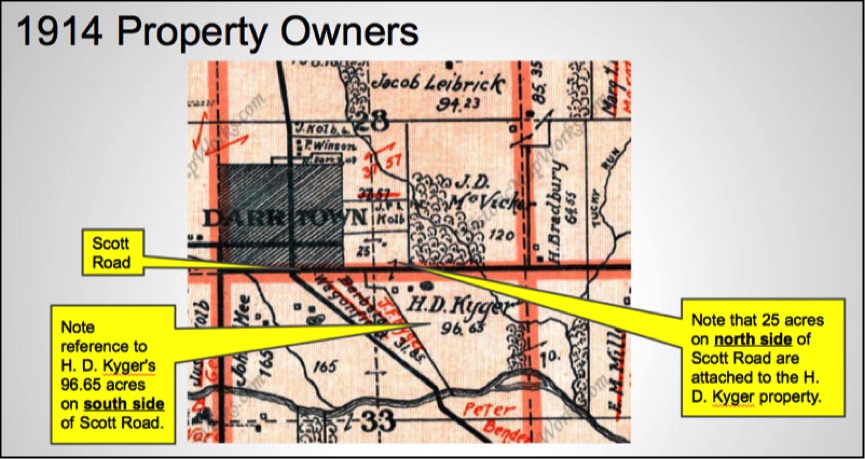
1914 MAP VERIFIES LOCATION OF KYGER'S 25 ACRE FIELD
The diagram in the following image confirms that H. D. Kyger owned the 25+ acres on the north side of Scott Road. This is consistent with the statement offered in the "Recollections" of Lawrence Baumann that describes the land in that north field being difficult to plow, because of its earlier use as a race track. Consequently, it follows that this 25-acre field is where H. D. Kyger constructed a race track for trotting horses. Map source: Historic Map Works.com
PLACE NAMES

The link at the end of this section connects to a webpage hosted by the Lane Public Library (Hamilton, Ohio) that provides a list of places in Butler County - many of which are no longer commonly used or known. Mr. Jim Blount, staff writer, is credited for compiling the list.
See the "Butler County Place Names" page at: https://sites.google.com/a/lanepl.org/butler/home
ONE ROOM SCHOOLS LOCATED ON 1914 MAP OF MILFORD TOWNSHIP
The "schools" section of this website provides information about, and images of, the Darrtown High School, the Collinsville Elementary School, and the Somerville School; see: Organizations/Schools.
In addition to the three 20th century schools named above, there was a time when there were other, usually one-room, schools, scattered throughout Milford Township.
RIGHT: This 1914 map, found at the historicmaps website, includes the number and location of several Milford Township schools.
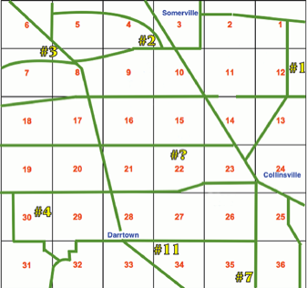
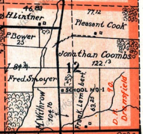
School No. 1 - in Section 12 (east side of State Road, north of Oxford-Middletown Road)
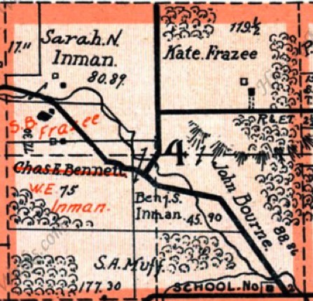
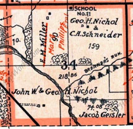
School No. 2 - in Section 4 (north side of Somerville Road, west of Baker Road)
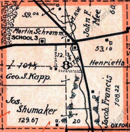
School No. 3 - in Section 8 (west of St. Rt. 177, north side of Somerville Road - in or near Jerico)
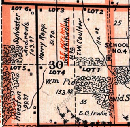
School No. 4 - in Section 30 (west of St. Rt. I77, south side of St. Rt. 73 - set back from road)
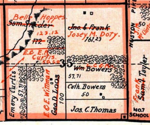
School No. 7 - in Section 35 (west side of Huston Road, north of Kinsinger Road)
School No. 11 - in Section 34 (south side of Scott Road, about 1 and 1/4 miles east of Darrtown)
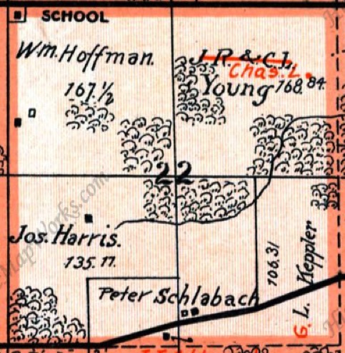
School / No. NOT KNOWN - in Section 22 (south side of Harris Road, about 1 and 1/4 miles east of St. Rt. 177).
If you know of additional school sites in Milford Township, please use the link in the footer to notify the Darrtown.com webmaster

1955 map of Darrtown area farmers
1955 directory - Butler Co. Farm Bureau

A list of MIlford Township residents from the year 1955 appears below.
The information was taken from the Butler County Farm and Business Directory that is featured above. The following, alphabetical list is organized by the names of the roads where the residents lived.
Return to MAPS
Return to MAPS
Click the following link to see an August 19, 1938 Cincinnati Post news item that mentions the rest area that would become the site depicted in the drawing at the right.