

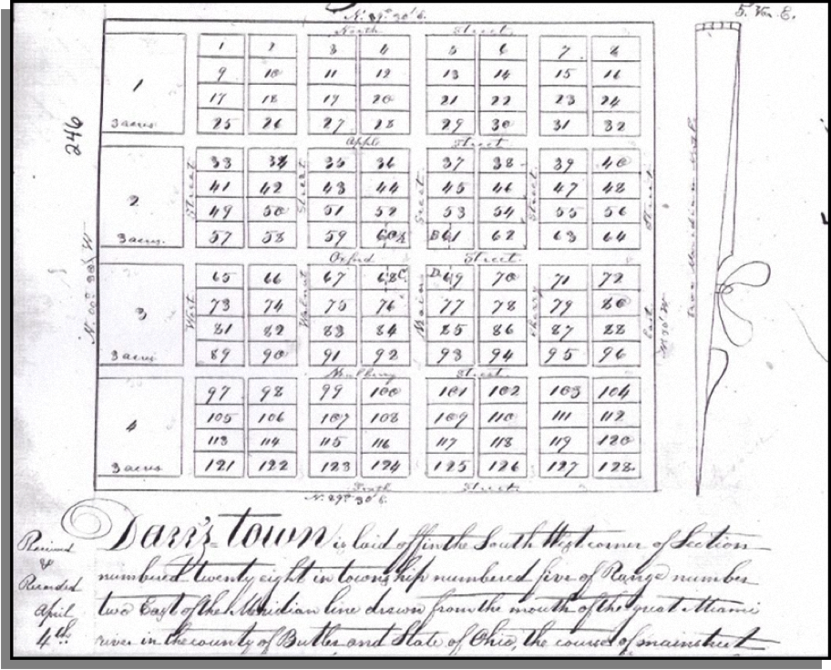
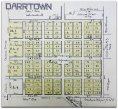
The following image shows the original plat of Darrtown, as filed, in the Butler County Court House, by Conrad Darr, on April 4, 1814. Darrtown native, Marvin Russell, found this plat at the Butler County Register's Office and contributed it to this site.
1814 PLAT OF DARRTOWN
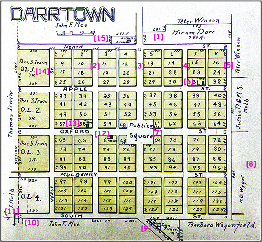
1868 MAP OF DARRTOWN

This 1868 map of Darrtown was contributed to this website by Valerie Elliott, the Smith History Library Manager, at the Lane Library in Oxford, Ohio, in September 2012. Valerie verified that this map as an authentic 1868 document.
This is the oldest Darrtown map in our collection that displays names of property owners.
When Conrad Darr designed the village, in 1814, he created 128 lots.
In 1868, three years after the end of the Civil War, 39 (or 30%) of the 128 lots were deeded to property owners.
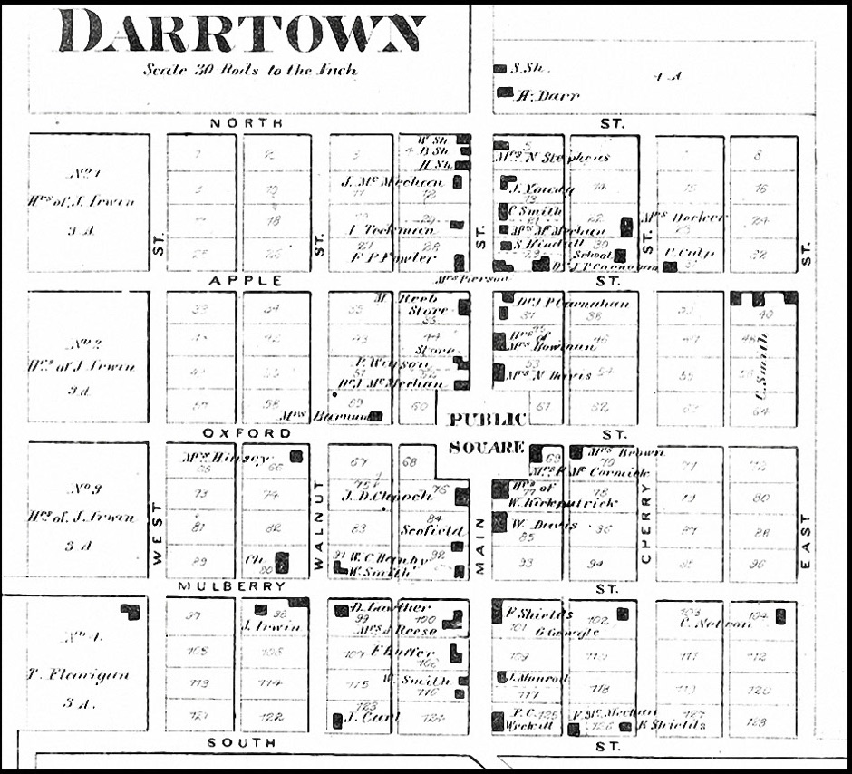
1868 MAP OF DARRTOWN - Enlarged and annotated
4 - (three structures - north to south) W Sh, B Sh, and H Sh
5 - Mrs. N. Stephens
12 - J. McMechan (J. McMechan is listed as one of Darrtown's postmasters; see Events / Postmasters.
13 - J. Young
20 - (one structure on southern half) I. Teckman
21 - (two structures - north to south) C. Smith and Mrs. McMechan
22 - Mrs. Decker
28 - F. P. Fowler listed as owner; Mrs. Pierson listed for the structure on Main Street.
29 - (three structures - two, north to south on Main Street and one at rear of southern half) S. Kindell in northern half, on Main Street; unidentified owner in southern half, on Main Street, and Dr. J. P. Carnahan at rear of southern half.
30 - School
37 - U. Culp
36 - M. Reeb (with note of "store")
37 - (two structures - north to south) Dr. J. P. Carnahan in northern structure; unidentified in southern structure.
45 - "Hrs" (House?) of Mrs. Bowman. (This structure is on the site that became the location of the Darrtown skating rink, the Francis filling station, and the Dees Grocery Store and Filling Station.)
52 - (three structures - north to south) P. Winston listed for two structures in the northern half (the northern most is identified as a "store") and Dr. J. McMechan is listed for the single structure in the southern half. (This lot, in 2012 is home to Don's Carryout and the Hitching Post tavern. Also, J. McMechan is listed as an owner of the Hitching Post and the original Darrtown postmaster.)
53 - Mrs. N. Davis (This structure became the home of "Cheesy" Brincefield in the 1930's and the Butterfield family in the 1950's. William J. Brincefield is listed as one of Darrtown's postmasters.)
59 - Mrs. Barnum
66 - Mrs. Hinsey
69 - Mrs. F. McCormick (This structure was located immediately east of where the MIlford Township Fire Department building stands in 2018.)
70 - Mrs. Brown
76 - J. D. Chooch (This name may be misspelled; the "Cooch" family name appears in records of Darrtown's past.)
77 - "Hrs" (house?) of W. Kirkpatrick (This structure is noted as one of several taverns in existence, during Darrtown's early years.)
84 - Scofield
85 - W. Davis (This was the location of Luther McVicker's garage during the 20th century.)
90 - "Ch" (Question; might this be an abbreviation for the word "church"? This site is the location of a former, brick school building that was converted to a residence in the 20th century.)
91 - W. Smith
92 - W. C. Hanby
98 - J. Irwin
99 - D. Lawther
100 - Mrs. A. Reese
101 - F. Shields
102 - G. Gowgle
104 - C. Netron
108 - F. Bufler (In 2015, this structure remains in the hands of the Bufler family.)
116 - W. Smith
117 - J. Manrod (designated for the northern half of this lot; there is no structure designated for souther half).
123 - J. Carl
125 - P. C. Wyclcitt OR Wyckitt (The spelling is unclear; might it be "Wyckoff" - which is a name that is part of Darrtown's past.)
126 - (two structures - west to east) F. McMechan is listed for the western structure and E. Shields is listed for the eastern structure.
=====================
There are several "outlying" lots on the west and east sides of the village (the east side is not visible in this map); on the west side, progressing from north to south, the owners are: No. 1, 2, and 3 - J. Irwin; No. 4 is T. Flanigan.
East of Main Street, on the north side of North Street, there is a four acre plot with two structures designated: "S. Sh." is listed for the north structure; "H. Darr" is listed for the south structure. Presumably, "H. Darr" is Hiram Darr and this property was eventually deeded to Johnny Darr, the last known Darr family member to live in Darrtown. This property became the site of the Harry Teckman home during the middle of the 20th century.
The red numerals that appear in the yellow boxes ON THE MAP (above)
correspond to the red numerals that appear, in the following list.
12
45
53
52
69
77
76
85
90
108
125
1868 Darrtown Property Owners - by LOT NUMBER
1914 MAP OF DARRTOWN
BELOW: The images below display a 1914 atlas that Albert Lindley purchased at a Hamilton, Ohio garage sale in the 1980's. The atlas measures approximately 18 inches wide by 21 inches long.
ABOVE: These three images show (left to right) the atlas cover, the face page and page 60 (with plats of Darrtown).
BELOW: This is an enlarged view of the 1914 map of Darrtown.
The bracketed numerals that appear on this map correlate to the list of notes that appears below the map.
Webmaster Note: The following enumerated items correlate with the bracketed numerals that appear on the 1914 map above.
[1] This Hiram Darr property is the (probable) site of John Darr's home and the land that Harry Teckman purchased for the construction of his home.
[2] Walnut Street / [3] Main Street / [4] Cherry Street / [5] East Street (not labeled on original map).
[6] Site of Darrtown's Town Hall (lot #31). The town hall is referenced in the 1826-27 section of Darrtown's historic time line.
[7] Site of the Knights of Pythias Hall.
[8] Site of Kyger's race track.
[9] Site of L. A. Miller home, which became the location of the Darrtown Telephone Company.
[10] & [11] The southern and western section lines of Milford Township Section #28 intersect at this point.
[12] Site of Milford Township High School; also known as Darrtown High School (later the home of the Fisherman's Press and (in 2012, the site of the Darrtown Baptist church.
[13] Site of Methodist church
[14] Site of Edot Park
[15] Site of Lutheran church


Return to MAPS
The links at the left connect to items located further down this page.
Return to MAPS
2023 MAP OF DARRTOWN - with lot numerals
The following map shows the lot numbering system that Conrad Darr created when he platted Darrtown, in 1814.
This map appears in two places at this website; here, with other Darrtown maps and also in the "Research" section - as an aid for persons who are researching Darrtown property ownership records.
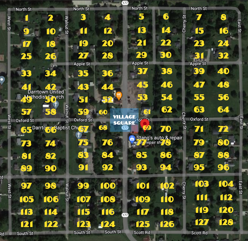
FYI: Lots 60, 61, 68, and 69 are four half-lots that comprise the village square. When Conrad Darr platted the village, he specified that these four half-lots would exist, as public property, in perpetuity. Presently (2023), this common ground, in the center of Darrtown, features the Veteran's monument, the Alston memorial, and the fire department building.