

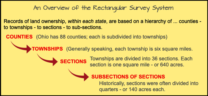
As the United States grew westward in the late 1700's, there arose a need for a standard consistent measurement system for establishing land ownership.
The Public Land Survey System (PLSS), also known as the Rectangular Survey System, was originally proposed by then U.S President Thomas Jefferson. The Rectangular Survey System (RSS) was formalized by the 1785 Land Ordinance Act and the 1787 Northwest Ordinance to mark large tracts of land that the country acquired in its early years (see a history of the RSS). The Rectangular Survey System is a method of surveying designed to divide the real property into specified plots.
Intro to the Public Land Survey System - aka, the Rectangular Survey System (RSS)
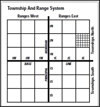
The Rectangular Survey System begins with the identification of the reference lines:
> The east-west reference line is known as called the Base Line.
> The north-south reference line is known as the Principal Meridian.
Astronomical observations determine an area’s baselines (latitude) and meridians (longitude). For example; there is a shared baseline at the Nebraska and Kansas border, as it follows the 40th parallel north (latitude), which is 40 degrees north of the earth's equator.
Meridans are measured (east and west) from the Prime Meridan (or zero degrees), which is located at Greenwich, England.
As you go to the east or west from a township's principal meridian, you will see the range lines established by the surveyors that are created at six nominal mile intervals.
Meanwhile, along the north or south of the Base Line are the township lines which are also at six nominal mile intervals. Each of the six by six nominal square miles is called a Township.
So, the township is therefore defined by determining the number of townships in north or south of the Base Line and the number of ranges in east or west of the principal meridian.
Take for example; the first township north of the Base Line and east of the Principal Meridian is defined as Township 1 North, Range 1 East. See the blue square in the drawing at the right.
If it is the fourth township south of the Base Line and third west of the Principal Meridian, we legally identify is as Township 4 South, Range 3 West.
Ranges and Townships
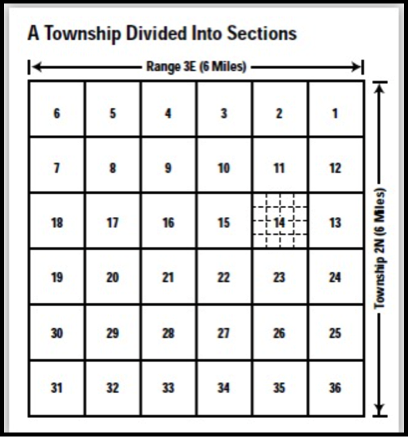
Sections
The 36-square mile township is a big area.
Therefore, it is further divided to 36 sections.
Since a township is six miles by six miles, each section is equivalent to one-square mile - or 640 acres. This is done by passing through each of the township lines parallel to the southern and eastern border of the township.
Sections within the township are numbered from 1 to 36 - starting in the northeast corner of the township and continuing (in serpentine form), ending with section 36, in the southeast corner of the township.
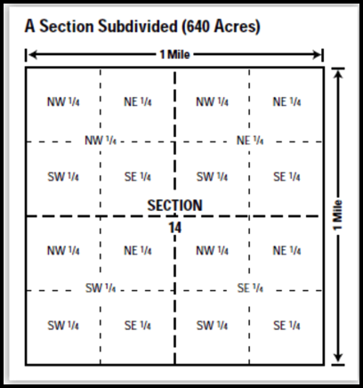
Further Subdivisions
Since a one-mile square does not identify a location very well, the 640 acres section is then further divided into fractional parts or subdivisions.
A section is divided into quarters and named as the northeast quarter, northwest quarter, southeast quarter, and a southwest quarter.
Each quarter of a section is equal to 160 acres, and ... can be further divided into quarters that are equivalent to 40 acres ... and further divided into even smaller units (usually, 10-acre portions are the smallest).
Every piece of land is defined according to the portion of the section it covers. For example, if someone purchased the northeast corner of section 22 (160 acres) of a township, the property would be known as the northeast quarter of section 22, township 1 north, range 1 east.
When the United States expansion occurred in the late 1700's, a system was needed to mark and maintain property boundaries. The Rectangular Survey System (RSS) was established.

Notable exceptions to the above...
> The state of Louisiana uses the term "parish,"rather than county.
> Land formations often prevent townships from being platted as rectangles and thus, the number of sections within a township will vary from the norm.

Understanding the Township and Range system will help locate items on file at the County Recorder's website.

The old professor says...
To see the RSS webpage, click this link.
Go to the Research page.
Go to the Research page.