


Improved interactive mapping technology has enhanced researchers' ability to study and share information electronically.
The Milford Township Trustees, along with staff members and students at Miami University joined efforts to produce an interactive map of the Darrtown cemetery.

The Milford Township Trustees partnered with Miami University professor, Dr. Robbyn Abbitt, and her students to produce the map. The students conducted the research and produced the map, at no cost to the township.
The interactive map is a work in progress. After the Darrtown cemetery mapping is completed, the focus will shift to the Collinsville cemetery.

On September 13, 2019, Mollie Hansel, Milford Township Fiscal Officer, provided the following description of the "Cemetery Mapping Project" that was developed cooperatively by the Milford Township Trustees and the Miami University Geospatial Analysis Center (GAC) in the Department of Geography (read more about the GAC below).
"Professor Robbyn Abbitt has taken our request to map out the Milford Township Cemeteries for a class she teaches at Miami. This project has taken two semesters to complete just the Darrtown Cemetery. This current semester we will work out the bugs and move on to Collinsville Cemetery.
The students who have created this website are: Brody Betsch, Elizabeth Foreman, Connor McDonald, Ryan Seim, Austin Alvarez, Caitlin Buchheim, Patrick Collins, Emma Farahay and Thomas Gerris. They have worked very hard on this project and we appreciate all that they have done!!"

MORE ABOUT the Miami University Geospatial Analyis Center:
The advanced GIS course (GEO 442/GEO 542 - Advanced Geographic Information Systems) is considered a service learning/experiential learning course at Miami. Each semester students work for real-world clients with needs that can be addressed using geospatial tools and techniques. Past clients include:
• Butler County MetroParks
• City of Oxford
• Hueston Woods State Park
• Butler County Regional Transit Authority (BCRTA)
• Miami University Institutional Relations
• Miami University Natural Areas
• Miami University Physical Facilities Department
• Miami University Police Department
• Globe Insurance Agency
• Promospark promotional company
THINGS TO KEEP IN MIND, WHEN VIEWING THE INTERACTIVE MAP:
The red lines indicate the burial plot boundaries.
The yellow dots indicate burial sites of military veterans.
The blue dots indicate burial sites of non-veterans.
There is a search box in the upper left corner of the map. The plus (+) and minus (-) signs provide a zoom feature.
Click the following link to access the Darrtown Cemetery Interactive Map.

WEBMASTER NOTE:
The willingness of the Milford Township Trustees to share the interactive map with this website is greatly appreciated.
A sincere "THANK YOU" is extended to Milford Township Trustees Amy Butterfield, Paul Gillespie, and Brad Mills.
The "cemetery mapping project" produced an interactive map of the Darrtown cemetery, which identifies the burial plots in the cemetery, as of the summer of 2019.
The red lines in the IMAGE AT THE RIGHT designate the burial plots. To determine the names associated with each plot, visit the Interactive Map, which may be accessed via the link that appears at the bottom of this page.
"Do not pity me for growing old. Tis a privilege denied to many."

ABOVE: This is an IMAGE of the interactive map. Click the link at the bottom of this page to access the map.
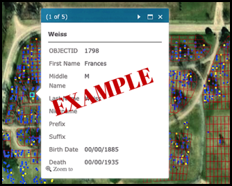
BELOW: This is an example of the window that opens, after clicking on a dot at the Darrtown Interactive Map.
√
Pioneer section Post-Pioneer section Plot Map Interactive map
√
Pioneer section Post-Pioneer section Plot map Interactive map